Bicycling information systems for bikeways
I've written about ideas to create community information networks--digital (see item #10, here, "PL #5: Creating a Silver Spring "Sustainable Mobility District" | Part 3: Program items 10-18 ) and analog--at the city and sub-city scale.
And I've suggested that bicycle route signage use branding and identity systems (see also the Better Bikeways signage project by Joseph Prichard and "Greater Knoxville Greenway signage project"), including map signage and signs with URLs/contact information for bikeway planning.
Dealing currently with the creation of cycletrack infrastructure in the Greater Takoma area because I sit on the neighborhood "Public Works and Infrastructure" Committee, I have been thinking about incorporating (1) community information boards; (2) murals; and (3) underpass lighting as part of the planning and construction process.
There is a community information board (and a Little Free Library) at the Rhode Island Metrorail Station "trailhead" on the Metropolitan Branch Trail, and a neighborhood association occasionally posts yard sign meeting notices at the R Street "trailhead," but these are exceptions.
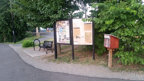
I think this is the only bulletin board placed on a DC bike trail.
This weekend I noticed that the "Bike to the Beach" fundraising event posted signs promoting the event on various trails and cycletracks throughout the city. I thought that was pretty smart, a well-targeted way to reach potential participants.
It reinforced the idea of the need for more systematic delivery of cycling-related information along bikeways, besides counters, and maybe digital information systems can be integrated into bike counter kiosks as one method.
A feed could be created as part of local and metropolitan bicycle planning, besides government agencies, it could include info from bicycle organizations and publications like the regional Spokes Magazine for the bicycling community, even ads (to help fund it).
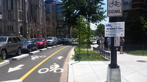
15th Street Cycletrack between V and W Streets NW
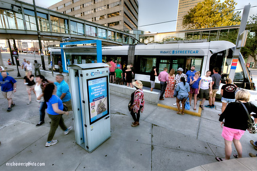
Kansas City Streetcar Stop with Smart City Post Kiosks. Flickr photo by Eric Bowers.
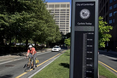
Bicycle counter, Broadway Street, Cambridge, Massachusetts. Photo by Michael Lee, Boston Globe. Why not make this a kiosk incorporating biking related notices and information?
I noticed from images that on a cycletrack in Sao Paulo they have digital advertising kiosks.
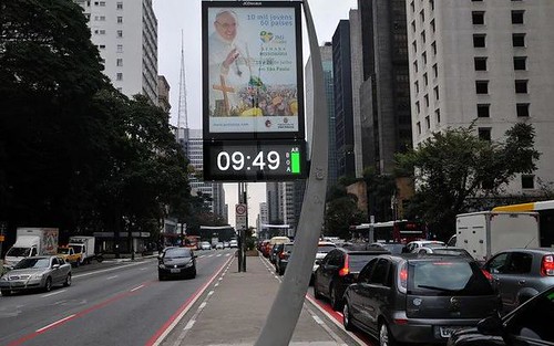
Digital ad signage on Avenida Paulist ciclovia/cycletrack, Sao Paulo.
Labels: community information systems, community media, digital/Internet, information design, information dissemination
posted by Richard Layman @ 3:43 PM&Permanent Link
![]()
![]()


3 Comments:
was out west.
Boulder does have a nice bike system. The infrastructure seems about the same here but the paint on the road seems to stick better there.
On thing to add to "signature streets" is landscaping to benefit bike riders. Far better out there as well than what we are getting. See the sad plants on 15th and w at the new bike intersection.
sad plants? was just there. But I was focused on the planting beds on the west side of the block.
... anyway, (1) I can't imagine you read all those Silver Spring pieces, but the points about the greenway cycletracks on Fenton St. and East-West would involve serious plantings.
(2) I used a bunch of photos from the Indianapolis Cultural Trail as examples. But I saw one in a pdf of a presentation from SF that wasn't from ICT (they too used ICT) and I am trying to track it down.
(3) interestingly, I didn't come up with it, but a landscape architect member of our ANC design committee (I am on the public works/infra committee) came up with an alternative routing for the MBT in our neighborhood that I think should be preferred, although it is a little out of the way (I am about to write about the general point, based on yesterday's article re I-66) because it will be more attractive to non hardcore riders.
Anyway, it could allow for an ICT type planting treatment on 3rd St. from Sheridan to Whittier.
(4) and specific to your point (ironically) while riding MBT yesterday in the afternoon sun, I thought about your general point about shade and realized (damn, I was taking photos today and forgot) that they screwed up by not planting trees on the east side of the trail, where the streetlights are placed. It'd have required a bit of an easement maybe from Ft. Myer, but Ft. Myer could get away with giving up a couple feet of their edge.
(5) I am trying to see if MRP will "Adopt the Trailhead" at Rhode Island Ave. ped. bridge including adding a trash can (part of a different as yet unwritten piece about RI area "public improvement district" improvements.
(6) but there is also a piece percolating about general placemaking improvements maybe.
====
never been to Boulder. maybe next year when we go to UT-ID we can set up our trip with a stopover in Denver. I haven't been able to convince Suzanne thus far.
definitely will add. Thanks.
Post a Comment
<< Home